Bosnia & Montenegro nature · 9 min read
Tara Canyon: Europe's Deepest Gorge and the Bridge One Man Blew Up to Save It
Tara Canyon — Europe's deepest at 1,333m. The Đurđevića Tara bridge story (built 1940, blown up 1942 by its own engineer). UNESCO Biosphere. How to see it from Mostar.
Quick answer
Tara Canyon — Europe's deepest at 1,333m. The Đurđevića Tara bridge story (built 1940, blown up 1942 by its own engineer). UNESCO Biosphere. How to see it from Mostar.
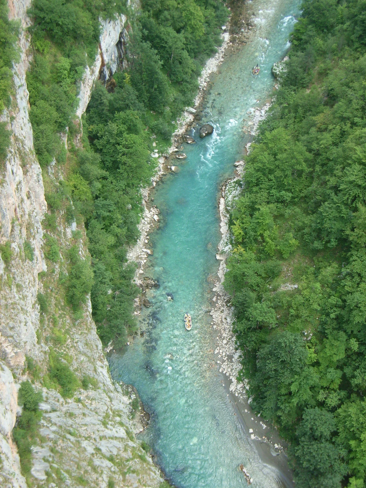
If you walk to the edge of Curevac viewpoint above Žabljak and look down, the river is a pale green thread at the bottom of a vertical drop the height of Stari Most stacked 78 times. That’s Tara Canyon: Europe’s deepest gorge, mostly unknown outside the rafting community, hidden because almost no road runs through it.
The numbers everyone quotes are part of why locals laugh when foreigners arrive. 1,333 meters deep at maximum. 82 km long. Water you can drink straight from a kayak. UNESCO Biosphere since 1977. And the bridge crossing it has a story you can’t make up.
The numbers
| Feature | Detail |
|---|---|
| Maximum depth | 1,333 m (around Tepca) |
| Average depth | 1,073 m |
| Length | 82 km — Bistrica (MN) to Hum (BiH) |
| Position globally | 2nd deepest worldwide (after Grand Canyon, 1,857 m) |
| Water quality | Class I (drinkable straight from river) |
| Water temperature | 7–11 °C even in summer |
| UNESCO designation | Man & Biosphere Reserve, 1977 |
| Inside | Durmitor National Park (UNESCO World Heritage 1980) |
| Border line | Last 36 km separate Montenegro and Bosnia |
| Endemic fish | Huchen (mladica, Hucho hucho) spawning ground |
The “Tear of Europe” nickname comes from the local saying that the Tara is what’s left when Europe finally decides to weep about its degraded rivers. Class I water purity at this scale survives nowhere else on the continent.
The Đurđevića Tara Bridge — the most expensive thing the Italians never crossed
The single most photographed object in Montenegro is a 365-meter concrete bridge that shouldn’t still be standing.
Built 1937–1940 by engineer Mijat Trojanović as part of the Belgrade–Adriatic road. Five arches, longest span 116 m, roadway 172 m above the river. At completion, the longest vehicular concrete arch bridge in Europe.
April 1942. Yugoslavia is under Axis occupation. Italian forces are pushing into Montenegro. The Đurđevića Bridge is the only feasible vehicular crossing of Tara Canyon for hundreds of kilometres — control it and you control the western Balkan road network.
Yugoslav partisans plan to destroy it. They need someone who knows where the structural weaknesses are. They find Lazar Jauković, one of the bridge’s own consulting engineers from the construction phase. Jauković agrees. He helps the partisans pack explosives into the southwesternmost arch. They blow it.
The bridge is unusable. The Italian advance stalls.
The Italians find Jauković. They take him to the bridge. They execute him standing on his own ruined arch.
The partisans rebuild the bridge after the war (1946). Today, a small monument at the southern abutment names Jauković. The bridge appears in the 1969 Yugoslav film Most (re-titled The Bridge internationally) and in the 1978 British film Force 10 from Navarone (with Harrison Ford).
You can drive across, walk across, or bungee jump from the longest arch (operates summer; ~€60).
What’s actually in the canyon
Black Pool (Crno jezero) — small glacial lake on the Žabljak side, 5 km from town. Mirror-flat, mountains reflected. Standard 30-minute lakeshore loop or 3-hour Veliki Crno + Mali Crno circuit.
Curevac viewpoint — the classic photo of the canyon from above. 1,625 m elevation, ~10 km drive plus 10-minute walk from a small parking area. Best in early morning before the canyon fills with cloud.
Tara rapids and beach access — the river’s edge is reachable at a few points but most of the canyon is too steep. Easiest swim spot: Šćepan Polje at the canyon’s mouth, where rafting trips end.
Tepča — small canyon village (population ~30), reachable by hairpin road. Used to be famous for its ancient walnut trees; many were cut for the local mill that operated until the 2000s. Atmospheric for a coffee.
Đurđevića Bridge bungee jump and zip-line — the long zip-line crosses the canyon at a slightly lower point than the bridge (~120 m above water). Both summer-season operations, easy to book on arrival.
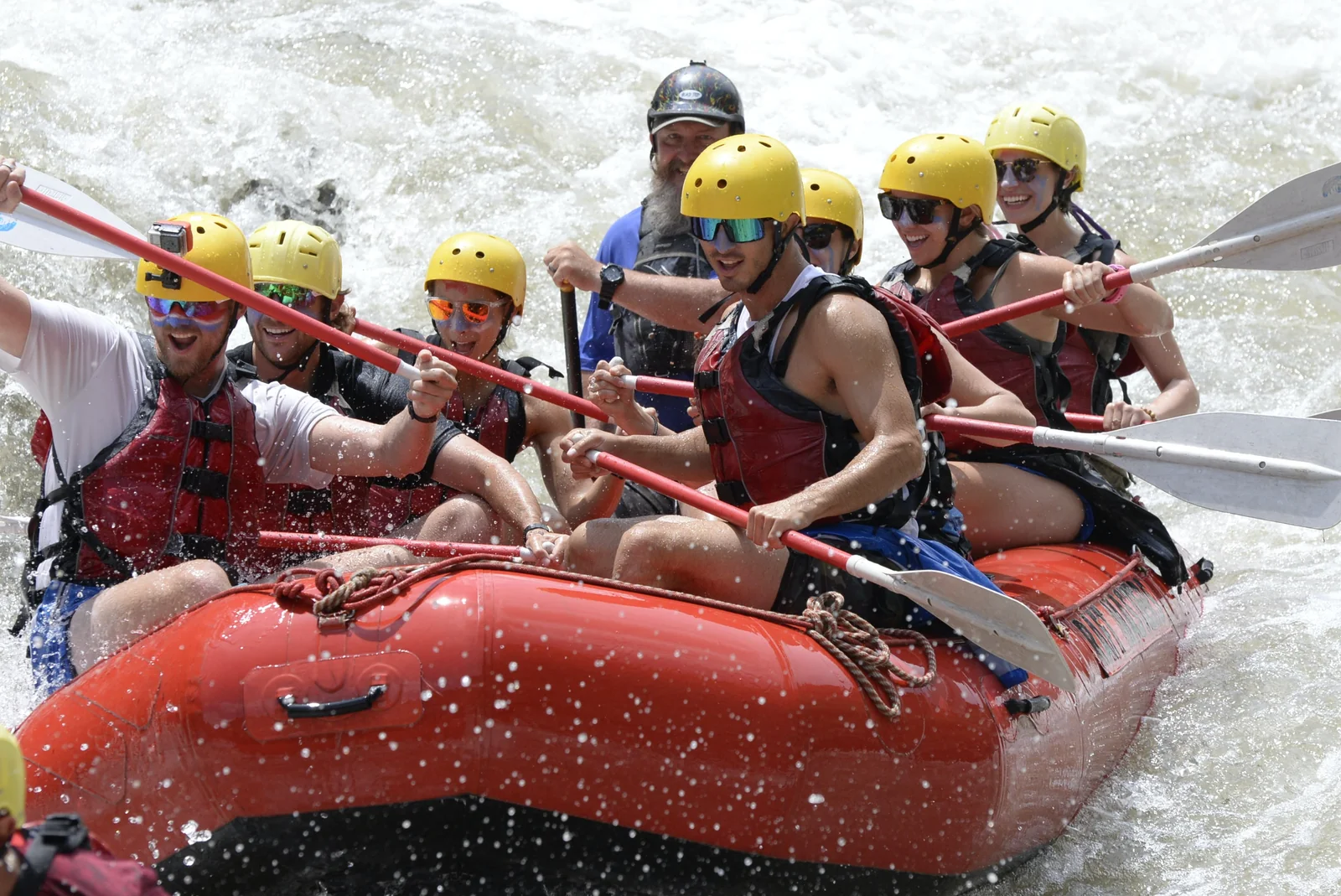
Rafting — the actual experience
Two standard routes:
One-day (14 km). Brstnovica → Šćepan Polje. Covers 22 of the canyon’s 55 named rapids. Class II–IV depending on water levels. Runs ~3 hours on the water. Highest water March–May (snowmelt); easier and warmer June–September. Most operators run this from the Bosnia side at Šćepan Polje — no passport needed; the put-in is right at the BiH–MN border.
Multi-day (60 km). Splits across 2–3 days, camping at riverside huts. Significantly more remote, fewer rapids per kilometre but the canyon walls reach maximum height around the upper section. Less commercial.
Most major rafting operators (Drina Tara, Highlander, Tara Tours) run organized trips with English guides, neoprene wetsuits, helmets, and lunch included. €50–80 for the one-day trip (transfer + raft + lunch). Bring swimsuit, towel, change of clothes for after.
Sometimes one raft a day flips here. Statistically rare (under 1%), commercial operators have decades of safety record without serious injury, and the river is shallow enough at the rapids that a swimmer can stand within metres. But it does happen — be honest with yourself about swimming ability before booking.
How to see it from Mostar
The canyon sits on the eastern edge of the Balkans — far from Mostar by drive time, close on the map.
Day trip route: Mostar → Foča via M-17 to Sarajevo, then turnoff (3.5 h). Continue past Sutjeska National Park to Šćepan Polje (rafting put-in). Total ~4 h to the put-in. Tight as a one-day return trip. Most travellers do this as a 2-day overnight in Žabljak or Foča.
2-day Tara + Sutjeska combo:
- Day 1: Drive Mostar → Foča (4 h). Afternoon hike or sightsee in Sutjeska NP, Tjentište monument.
- Day 2: Morning rafting from Šćepan Polje (8:00–13:00). Drive back to Mostar (4 h) by evening.
3-day Montenegro loop: add Žabljak (Durmitor NP) and Đurđevića Bridge to the above.
Practical: No public transport reaches the canyon directly. Self-drive or private transfer from Mostar (we can arrange — message via WhatsApp). Rafting season April–October; July–August is peak — book ahead.
What to combine it with
- Sutjeska National Park — Maglić (Bosnia’s highest peak), Perućica primeval forest, on the route
- Tara River rafting tour — our organized Tara rafting day from Mostar
- Konjic to Sarajevo — natural waypoint on the M-17 driving route
- Mostar travel guide — base for the trip
FAQ
Frequently asked questions
How deep is Tara Canyon, exactly?
**1,333 meters at its maximum** (around the Tepca area), with an average depth of 1,073 m along its 82 km length. That makes it **the deepest canyon in continental Europe** and the **second deepest in the world** after the Grand Canyon (1,857 m). Some Balkan tourism sites still claim 'deepest in the world' — that's outdated. Sulak Canyon in Russia (Dagestan) was confirmed at 1,920 m in 2010, pushing Tara to second in Europe by some measures.
Where is Tara Canyon?
Straddles the **Bosnia–Montenegro border**. Length 82 km from **Bistrica** (near Šćepan Polje, Montenegro) to **Hum** (Bosnia). The last 36 km form the actual border between the two countries. Most visitors approach from the Montenegrin side via **Žabljak** (1,456 m, gateway to Durmitor National Park). From Bosnia, the canyon is most accessible via **Foča** and the [Sutjeska National Park](/sutjeska-national-park/) road.
Can I really drink the water?
Yes — **Class I water quality**, drinkable straight from the river in most sections. UNESCO recognized this in 1977 when the canyon entered the **Man and Biosphere** programme. The Tara is one of Europe's last unpolluted major rivers, partly because it carves through limestone karst (which filters water as it percolates underground), partly because there's almost no industry along its course.
What's the deal with the Đurđevića Tara Bridge?
The 365 m concrete arch bridge crossing the canyon at **172 m above the water** — the iconic image of the canyon. Designed by engineer **Mijat Trojanović**, built 1937–1940. At completion it was the **longest vehicular concrete arch bridge in Europe**. In 1942, during Italian occupation, Yugoslav partisans (with help from one of the bridge's own engineers, **Lazar Jauković**) destroyed the southwesternmost arch to halt the Italian advance. Italy captured Jauković and **executed him on his own bridge**. The bridge was rebuilt 1946. Today: tourists, bungee jumping, and a small monument to Jauković at the southern end.
Is rafting any good?
Among the **best whitewater in Europe**. Two main routes: **One-day (14 km)** Brstnovica → Šćepan Polje, covering 22 of the canyon's 55 named rapids; **Multi-day (60 km)** from upper canyon down. **Class II–IV** rapids depending on water level (highest March–May). Season runs **April–October**. The canyon walls during the run are 1,000+ m straight up — the experience is partly the rapids, partly the scale.
Day trip from Mostar?
**Tight but doable.** ~3.5 hours each way via Foča and the Sutjeska road. Realistically: leave Mostar 6:00, at Đurđevića Bridge by 10:00, raft (or hike to viewpoint), drive back, in Mostar by 21:00. **Better as a 2-day trip** — overnight in Žabljak or Foča, fit in [Sutjeska NP](/sutjeska-national-park/) too.