Kravica Waterfalls · 7 min read
Where Is Kravica Waterfall? GPS, Map & How to Find It in 2026
Exact location of Kravica Waterfall — GPS coordinates, geographic context within Herzegovina, and clear driving directions from Mostar, Dubrovnik, Split, and Sarajevo.
Quick answer
Exact location of Kravica Waterfall — GPS coordinates, geographic context within Herzegovina, and clear driving directions from Mostar, Dubrovnik, Split, and Sarajevo.
Quick answer: Kravica Waterfall is at 43.158°N, 17.589°E in southern Bosnia (Herzegovina region), 40 km south of Mostar on the Trebizat River. The closest village is Studenci (5 km), the closest town is Ljubuški (10 km), and the parking lot is on a plateau above the falls (5–10 min walk down a paved path to the swim platform). Search ‘Kravica Waterfall’ or ‘Vodopad Kravica’ in Google Maps and you’ll land at the pin.
For full destination details (entry, swim conditions, what to bring) see our Kravica Waterfall pillar guide. For all transport options see Mostar to Kravica.
Geographic context
| Country | Bosnia and Herzegovina |
| Region | Herzegovina (southern half) |
| Canton | West Herzegovina Canton |
| Closest village | Studenci (5 km) |
| Closest town | Ljubuški (10 km north) |
| Closest hub town | Čapljina (12 km east) |
| GPS (canonical) | 43.158°N, 17.589°E |
| Elevation | ~150 m above sea level |
| River | Trebizat (a karst river that disappears underground 9 times along its 51 km length) |
| Park manager | Ljubuški municipality (commercial parks operator) |
Distance from major cities
| From | Distance | Drive time | Notes |
|---|---|---|---|
| Mostar | 40 km | 35–45 min | Most common origin; via M17 + Pocitelj-Zvirovici motorway |
| Medjugorje | 20 km | 25 min | Catholic pilgrimage site |
| Čapljina | 12 km | 15 min | Closest hub town |
| Ljubuški | 10 km | 12 min | Closest larger town |
| Studenci | 5 km | 7 min | Closest village |
| Dubrovnik | 110 km | 2 hours | Cross border at Doljani / Klek |
| Split | 135 km | 2.5 hours | Cross border at Doljani |
| Sarajevo | 170 km | 2.5–3 hours | Through Neretva canyon |
| Sarajevo airport (SJJ) | 165 km | 2.5 hours | Add 30 min for arrivals processing |
| Belgrade | 415 km | 6–7 hours | Long haul, only as part of broader Balkans trip |
How to find it on Google Maps
Three reliable search strings:
Kravica Waterfall— English, drops a pin at the gateVodopad Kravica— Bosnian, same pin- GPS
43.158, 17.589— paste directly
There are several places named “Kravica” in Bosnia (it’s a common geographic name). The waterfall is sometimes confused with the village of Kravica near Bratunac in eastern Bosnia — different place entirely. Use the GPS coordinates above if your search returns ambiguous results.
Driving directions
From Mostar (most common)
- Head south on Bulevar (M17 / E73) out of Mostar
- Continue south past Buna and Blagaj turnoffs
- Take the new Pocitelj-Zvirovici motorway (€1–3 toll) for the fastest route — see our highway guide
- Exit at Zvirovici, follow brown tourist signs west to Kravica (8 km on regional road)
- Park in the gate lot (free)
- Walk 5–10 min down the paved path to the falls
Trust brown tourist signs over older GPS units that may not have the new motorway.
From Dubrovnik
- Head north on D8 toward the Croatian-Bosnian border
- Cross at Doljani (or Klek if rerouted) — passport required
- Continue north on M6 toward Ljubuški
- At Ljubuški, follow brown signs east to Kravica (10 km)
- Park, walk down
Border crossing time: 10–30 min depending on season.
From Split
- Head south on D8 along the coast
- Cross at Doljani — passport required
- Continue inland on M6 toward Ljubuški and Kravica
Same brown tourist sign navigation once across the border.
From Sarajevo
- Head south on M17 / A1 through the Neretva canyon (genuinely scenic)
- Pass Konjic and Jablanica
- Through Mostar (or use the bypass if not stopping)
- Continue south on the Pocitelj-Zvirovici motorway
- Exit at Zvirovici, follow brown signs to Kravica
Total ~3 hours; an early-morning start is essential to make this a same-day return.
What’s around it (the Herzegovina cluster)
Kravica sits at the heart of a cluster of attractions, all within 30 minutes’ drive:
- Pocitelj — 20 min north, Ottoman fortified village. See our Pocitelj guide.
- Kočuša Waterfall — 15 min west, smaller falls included in your Kravica ticket
- Mogorjelo — 20 min south, 4th-century Roman villa ruins (free)
- Blagaj Tekke — 30 min north, Sufi dervish house at the Buna spring source. See Blagaj Tekke guide
- Hutovo Blato — 30 min south, wetland nature reserve, birding hotspot
- Vjetrenica Cave — ~60 min south near Ravno, ecologically diverse cave system. See Vjetrenica guide
- Medjugorje — 30 min northwest, major Catholic pilgrimage site
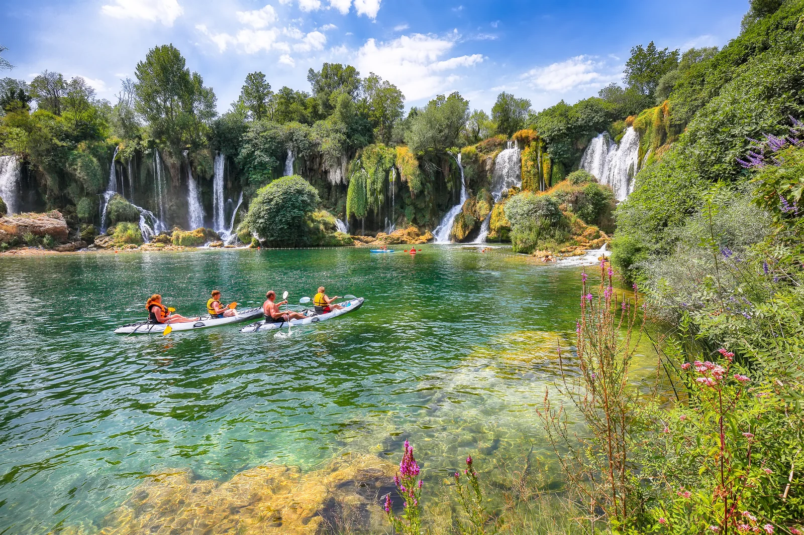
- Trebizat River — same river that powers Kravica; kayakable upstream. See Trebizat kayaking
This proximity is why a single day-trip from Mostar can comfortably cover Kravica + Pocitelj + Blagaj — they’re all on the same southern axis.
Visit on a guided tour
Our Kravica Waterfall day tour from Mostar packages Kravica with Fortica Sky Walk, Blagaj Tekija, Bunski Kanali, and Počitelj in one full day. €50/person, hotel pickup, English guide, max 8 guests.
For custom multi-stop trips, our private transfers from Mostar start at €60/vehicle for short routes. WhatsApp +387 62 694 887.
Related guides
- Kravica Waterfall pillar guide — full destination guide
- How to get to Kravica from Mostar — all 7 transport options
- Kravica price guide — entry, parking, activities, total cost
- Pocitelj-Zvirovici highway — navigation on the new motorway
- Pocitelj village guide — combine with Kravica
- Blagaj Tekke — third standard stop on this route
FAQ
Frequently asked questions
What's the exact GPS for Kravica Waterfall?
**43.158°N, 17.589°E** is the canonical pin at the gate parking lot. In Google Maps search 'Kravica Waterfall' or 'Vodopad Kravica' — both work. The coordinates land you at the upper plateau parking; the actual waterfall and swim platform are a 5–10 minute paved-path walk down the cliff. Note: Kravica is sometimes spelled 'Kravice' (plural form in Bosnian); both refer to the same place. The official Bosnian name is **Vodopad Kravica** ('Kravica Waterfall').
What region of Bosnia is Kravica in?
**Herzegovina** — the southern half of Bosnia and Herzegovina, specifically the **West Herzegovina Canton**. It sits between the towns of **Studenci** (5 km away, the closest village), **Ljubuški** (10 km north), and **Čapljina** (12 km east). The region is karstic limestone country with underground rivers and travertine formations — Kravica itself is a large travertine cascade on the Trebizat River. Mediterranean-influenced climate (hot dry summers, mild damp winters).
How far is Kravica from Mostar?
**40 km / 35–45 minutes by car** south of Mostar via the M17 highway and the new Pocitelj-Zvirovici motorway section. By guided tour from Mostar, you arrive around 12:00 (after Blagaj and Fortica stops) or 10:00 if direct. Public transport (bus + taxi) takes 90 minutes one-way. See our **[full Mostar to Kravica transport guide](/how-to-get-to-kravice-waterfalls-from-mostar/)** for all 7 options compared.
How far is Kravica from Dubrovnik?
**110 km / 2 hours by car** north of Dubrovnik via the Doljani or Klek border crossing. Day-trippable from Dubrovnik but tight — most travellers come for an 8–10 hour day. **Pro tip**: combine with Mostar (Kravica is on the way) and stay overnight in Mostar to avoid the back-to-back 4 hours of bus on a single-day return. Bring passport + green-card vehicle insurance for the rental.
How far is Kravica from Split?
**135 km / 2.5 hours by car** southeast of Split via the M17 corridor and Doljani border crossing. Day-trippable but a long day (4 hours each way). Most Split day-tours are 12 hours total and combine Mostar with Kravica for a full Herzegovina taste. Same passport + green-card requirements as the Dubrovnik route.
How far is Kravica from Sarajevo?
**170 km / 2.5–3 hours by car** south of Sarajevo via the M17 highway through the Neretva canyon. Day-trip from Sarajevo is doable but long — most Sarajevo-origin tours are 11–12 hours and combine Konjic (with Tito's bunker), Jablanica, Mostar, and Kravica. The drive is genuinely scenic — the Neretva canyon section is one of the better short rail/road routes in the Balkans. See our **[Sarajevo to Mostar guide](/how-to-get-from-sarajevo-to-mostar/)**.
What's the closest town to Kravica?
**Studenci** (5 km) is the closest village — small, agricultural, with a few small guesthouses and the Trebizat kayak put-in points. **Ljubuški** (10 km) is the closest larger town with banks, supermarkets, the Humac Monastery Museum included in your Kravica ticket. **Čapljina** (12 km) is the closest hub town with multiple hotels, restaurants, the train station for the Sarajevo–Ploče line, and connections to Mostar. **Medjugorje** (20 km) is the closest internationally-recognised stop — major Catholic pilgrimage site.
Where exactly is the parking lot vs the waterfall?
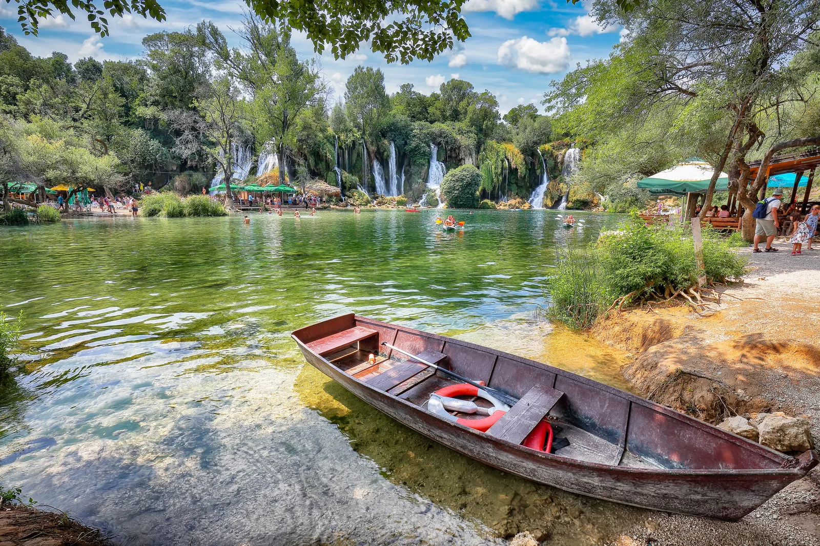
**Parking is on the upper plateau** above the falls, at the GPS pin (43.158°N 17.589°E). From there, a paved descent path takes you 130 m down in elevation over 400 m of distance to the swim platform at the base of the falls. The path has handrails and stairs at sections, takes 5–10 minutes down, 10–15 minutes back up. **Mini-train shuttle** runs June–September between parking and the lower platform if you have mobility limits. Don't park at the M17 highway exit and walk — the gate is 1 km along the access road.
Is Kravica visible from the highway?
**No — Kravica sits in a canyon below the main road and isn't visible from the M17 highway** even when you drive past the exit. There's a **viewing point** about 1 km north on a side road that gives a partial overhead glimpse, but the proper view requires entering the park (€10 entry, free Nov–Mar). Don't expect a 'roadside' view — the falls reveal themselves only after you walk down the descent path from the gate.
Can I see Kravica + Pocitelj + Blagaj in one day?
**Yes — this is the classic Herzegovina day trip from Mostar.** Geography works in your favour: Blagaj is 12 km southeast of Mostar, Pocitelj is 30 km south, Kravica is 40 km south. All three are within a 45-minute radius of Mostar, on essentially the same southern axis. **Standard day**: Mostar → Blagaj → Pocitelj → Kravica → Mostar, ~8 hours total with stops. Our **[Kravica day tour from Mostar](/kravica-waterfall-tour-from-mostar/)** packages exactly this loop at €50/person.
What's the postal address or address-style location?
Kravica Nature Park doesn't have a traditional street address (it's in protected karst countryside). For navigation use **'Kravica Waterfall, Studenci'** or the GPS **43.158°N 17.589°E**. **Postal closest**: 88300 Čapljina (regional administrative centre). The park is operated by Ljubuški municipality through a commercial parks-management arrangement; for formal correspondence the Ljubuški municipal address (88320 Ljubuški) is used.
What's nearby once I'm there?
Within 30 minutes' drive: **Pocitelj** (Ottoman fortified village, 20 min north), **Kočuša Waterfall** (smaller falls, included in your Kravica ticket, 15 min away), **Mogorjelo** (4th-century Roman villa ruins, 20 min south near Čapljina), **Hutovo Blato** (wetland nature reserve, 30 min south), **Vjetrenica Cave** (one of Europe's most ecologically diverse caves, 60 min south near Trebinje), **Medjugorje** (Catholic pilgrimage town, 30 min northwest), **Ljubuški** (fortress + small town, 15 min north). The Trebizat River is also kayakable — see our **[Trebizat kayaking guide](/trebizat-kayaking/)**.