Bosnia nature · 8 min read
Neretva: The Emerald River That Built Mostar (and Stayed Cold Enough to Drink in August)
Neretva — 225 km river from 1,227 m Lebršnik down to the Adriatic. Class I water, 7–11°C in summer, endemic softmouth trout, the Mostar Bridge runs over it. Visit guide.
Quick answer
Neretva — 225 km river from 1,227 m Lebršnik down to the Adriatic. Class I water, 7–11°C in summer, endemic softmouth trout, the Mostar Bridge runs over it. Visit guide.
The Neretva is the only river in Bosnia that flows to the Adriatic — and the only river in Europe that lets you swim in 8°C water under a 16th-century Ottoman bridge with traffic crossing above your head. Most travellers see the Neretva for thirty seconds in Mostar before moving on. It runs 225 kilometres and shapes everything in southern Bosnia.
If you want to understand Hercegovina, drive the river — top to bottom, Konjic to Ploče — over a couple of days. Almost everything that matters in the region happens within 5 km of the Neretva.
The numbers
| Feature | Detail |
|---|---|
| Length | 225 km (208 BiH + 22 Croatia) |
| Source | 1,227 m elevation, Lebršnik / Zelengora mountains |
| Mouth | Adriatic Sea at Ploče, Croatia |
| Drop | 1,227 m over total length |
| Discharge | 341 m³/s average at mouth |
| Water temp (summer) | 7–11 °C |
| Water purity | Class I in upper course; Class II below Mostar |
| Hydroelectric dams | 4 main: Jablanica, Grabovica, Salakovac, Mostar |
| Largest town | Mostar (~100,000) |
| Endemic species | Softmouth trout (Salmo obtusirostris), Vulnerable |
Where it comes from, where it goes
The river rises in the Lebršnik and Zelengora highlands of eastern Hercegovina, around 1,227 m elevation. The first 30 km are upper canyon — almost no settlements, dense beech forest, water emerging from karst springs at near-constant 7°C. This is the Upper Neretva — a wilderness section reachable mostly by 4WD or hike.
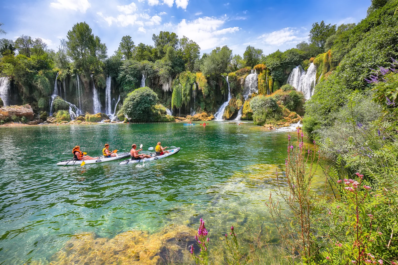
By Konjic (1.5 hours north of Mostar), the canyon widens slightly. This is where most rafting trips put in. The river is fast, jade-green, and so cold you actually feel it through a wetsuit.
Through Jablanica (with its lake) and the dramatic canyon below Konjic — limestone walls 600–800 m straight up on both sides for nearly 30 km. The 1943 Battle of Neretva was fought along this canyon. Today the M-17 highway runs alongside it; the drive Mostar → Sarajevo is one of the more scenic in the Balkans precisely because of this.
The Mostar section (where you encounter the river as a tourist) is just one moment in a much longer course. Below Mostar the canyon opens into the Hercegovinian valley — vineyards, tobacco fields, Pocitelj on its hill. The river slows. By Čapljina it’s flat, agricultural, draining into the Croatian delta around Metković and out to sea at Ploče.
The Neretva is also the only river to keep its name from source to sea in the region — locals consider it a single living thing across all 225 km. You’ll see this in cafés in Konjic and Metković selling beer with the same Neretva logo, regardless of which country they’re in.
The temperature thing
It’s worth saying again because most people don’t believe it until they try. The Neretva is 7–11 °C even in August. The summer Adriatic 30 km away is 25–28 °C. Crossing over the water at noon in July you assume the river is comfortable. It is not.
Cause: karst geology. The water arriving at Mostar today entered the limestone aquifer months or years ago, percolated underground past sun, and emerges at near-cave temperature. Same reason the Buna spring at Blagaj (a Neretva tributary) sits at a permanent 7°C.
For locals this is a feature: drinking water on tap, free swimming pools that don’t get bath-warm, and the Mostar diving tradition at Stari Most — 24 m drop into water cold enough that hitting it wrong is dangerous. The dive is not just a height stunt. It’s a temperature stunt.
Rafting, kayaking, fly-fishing
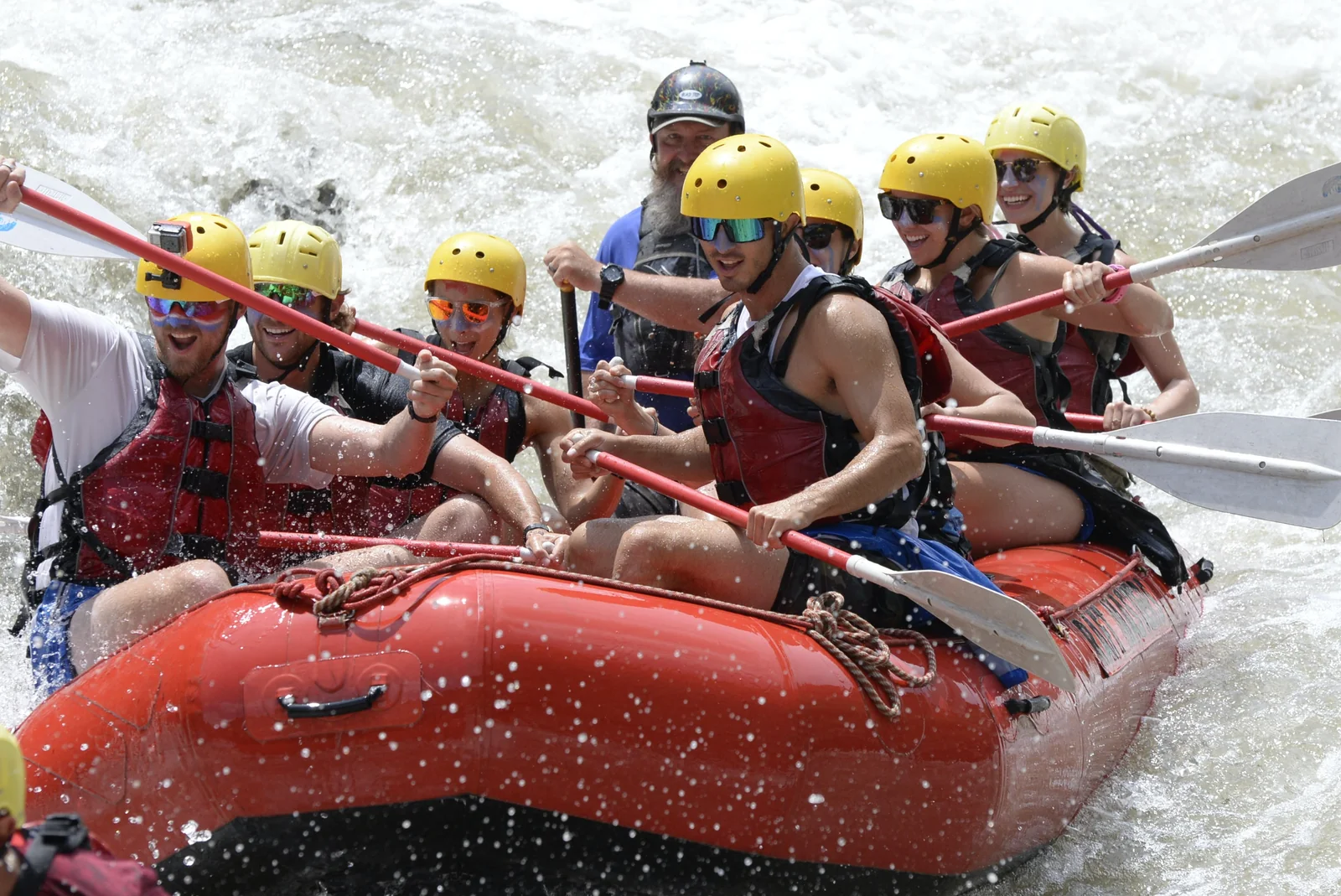
Rafting (Konjic section). Class II–III rapids, 18–25 km depending on operator, ~3 hours on the water. Easier than Tara Canyon — friendlier intro for first-timers. Season April–October. Most operators offer transfer from Mostar (~1 hour). See our Konjic rafting guide and mini-rafting for half-day options.
Kayaking. Lower Neretva (around Mostar–Pocitelj) is calm enough for sea kayaks. Upper canyon needs whitewater experience. Several outfits in Mostar and Konjic rent gear.
Fly-fishing. The Neretva is a legendary trout river — endemic softmouth (catch & release only), brown trout, grayling. Best sections: upper canyon between Konjic and Jablanica (permits required, day rate ~€20). The endemic softmouth must be released; brown trout above 25 cm can be kept by some permits. Most experienced fly-fishers regard it as one of the last wild trout rivers in Europe.
The dams (and the controversy)
Four major dams on the main stem: Jablanica (1955), Grabovica (1981), Salakovac (1980), Mostar (1987). Plus dams on tributaries (Rama, Trebišnjica). Combined output: ~30% of BiH’s electricity.
This is a point of friction. Local environmental groups argue the dams degrade endemic species (the softmouth trout almost went extinct after Jablanica reservoir flooded its spawning grounds in 1955). Plans for a fifth dam at Ulog (upper canyon) have been live since 2010s and are repeatedly blocked by activist campaigns and EU pressure. As of 2026, no new dam has been built. The Save the Blue Heart of Europe movement coalesced around opposition to Balkan dam projects, and the upper Neretva is one of its flagship causes.
Worth knowing as context. The river you see from Stari Most is, in its present form, artificially controlled — the water level depends on what Jablanica and Salakovac decide to release upstream.
How to actually experience the Neretva
The fast version: stand on Stari Most. Look down. Done.
The proper version (1 day): drive Mostar → Konjic, stop at Jablanica Lake, raft Konjic section, drive back. Combine with Konjic day trip.
The full version (2–3 days): drive the river top-to-bottom. Mostar → Capljina (Pocitelj, vineyards) → Croatian delta (Metković, Ploče); then back upstream Mostar → Jablanica → Konjic → upper canyon if you have 4WD. Stay overnight at a guest house above the canyon — the night sound of water 600 m below the road is something most travellers don’t realize they were missing.
Best months: May–October. Late June when wildflowers in the canyon are at peak. Avoid mid-July to mid-August at peak rafting time if you want the river to yourself.
What to combine it with
- Konjic rafting guide — the standard rafting day from Mostar
- Mini rafting Konjic — half-day version
- Battle of Neretva — WWII story along this exact valley
- Jablanica Lake guide — reservoir at the upstream dam
- Mostar travel guide — the city the river built
- Pocitelj — Ottoman fortress town overlooking the river south of Mostar
- Tara Canyon — the Neretva’s bigger, deeper neighbour two valleys east
FAQ
Frequently asked questions
How long is the Neretva?
**225 km total** — 208 km in Bosnia & Herzegovina, 22 km in Croatia. **Source:** 1,227 m elevation in the Dinaric Alps (between **Lebršnik** and **Zelengora** mountains in eastern Hercegovina, near the Montenegrin border). **Mouth:** the Adriatic Sea at Ploče, Croatia. The vertical drop is **1,227 m over the river's length** — steep enough to power four hydroelectric dams.
Why is the water so cold?
**7–11 °C even in August.** It's a karst river — most of the water enters from underground springs that fed off snowmelt in the Dinaric Alps and stayed inside limestone caves before emerging. The springs maintain a near-constant temperature year-round. **You will not adapt to swimming in it.** Five seconds in is shock; thirty seconds in is genuinely painful for most people. Locals jump in from Stari Most as a test of nerve, not comfort.
Why is it green?
**Calcium carbonate and copper-mineral runoff** dissolved into the water from the limestone karst it carves through. The same chemistry that makes the Plitvice Lakes and Krka lakes green-blue — but the Neretva carries more dissolved minerals because it cuts deeper into older karst. The colour ranges from **emerald in deep pools** to **near-translucent jade** in shallow rapids. Brightest in late spring after snowmelt.
Is the Neretva navigable?
**The lower 22 km in Croatia** (delta near Metković–Ploče) is navigable by small boats and canoes — flat, slow, agricultural. **Above Mostar**, the river is Class II–III rapids in Konjic-Jablanica section (rafting), wild and unnavigable in upper canyon between Konjic and Foča-area headwaters. Almost no commercial river traffic anywhere. The Neretva is a recreation river, not a transport river.
What's the endemic softmouth trout?
**Salmo obtusirostris** — the Neretvan softmouth trout, also called *mekousna pastrmka*. Endangered endemic — only lives in the Neretva system and a few tributaries. Adults reach 50 cm. Distinguishable from regular trout by its smaller, blunter mouth (hence 'soft mouth'). Conservation work has stabilized the population since 2000s but it remains classified IUCN Vulnerable. **Catch & release only**; no commercial fishing.
What was the Battle of Neretva?
**February–March 1943.** Yugoslav Partisans under Tito (~20,000 fighters + ~4,500 wounded) were trapped between Axis forces (German, Italian, Ustaše, Chetnik) along the upper Neretva valley near Jablanica. **Tito ordered the destruction of all bridges** to feign retreat south, then crossed the **partly-demolished iron Jablanica bridge** with the wounded under fire. Operation succeeded — Partisans escaped encirclement. ~12,000 Partisan casualties. Subject of the 1969 Yugoslav-American film *The Battle of Neretva* (Yul Brynner, Orson Welles, Franco Nero, Sergei Bondarchuk; Picasso designed the poster). See [Battle of Neretva guide](/battle-of-neretva/) and [Jablanica Lake](/jablanica-lake-guide/).